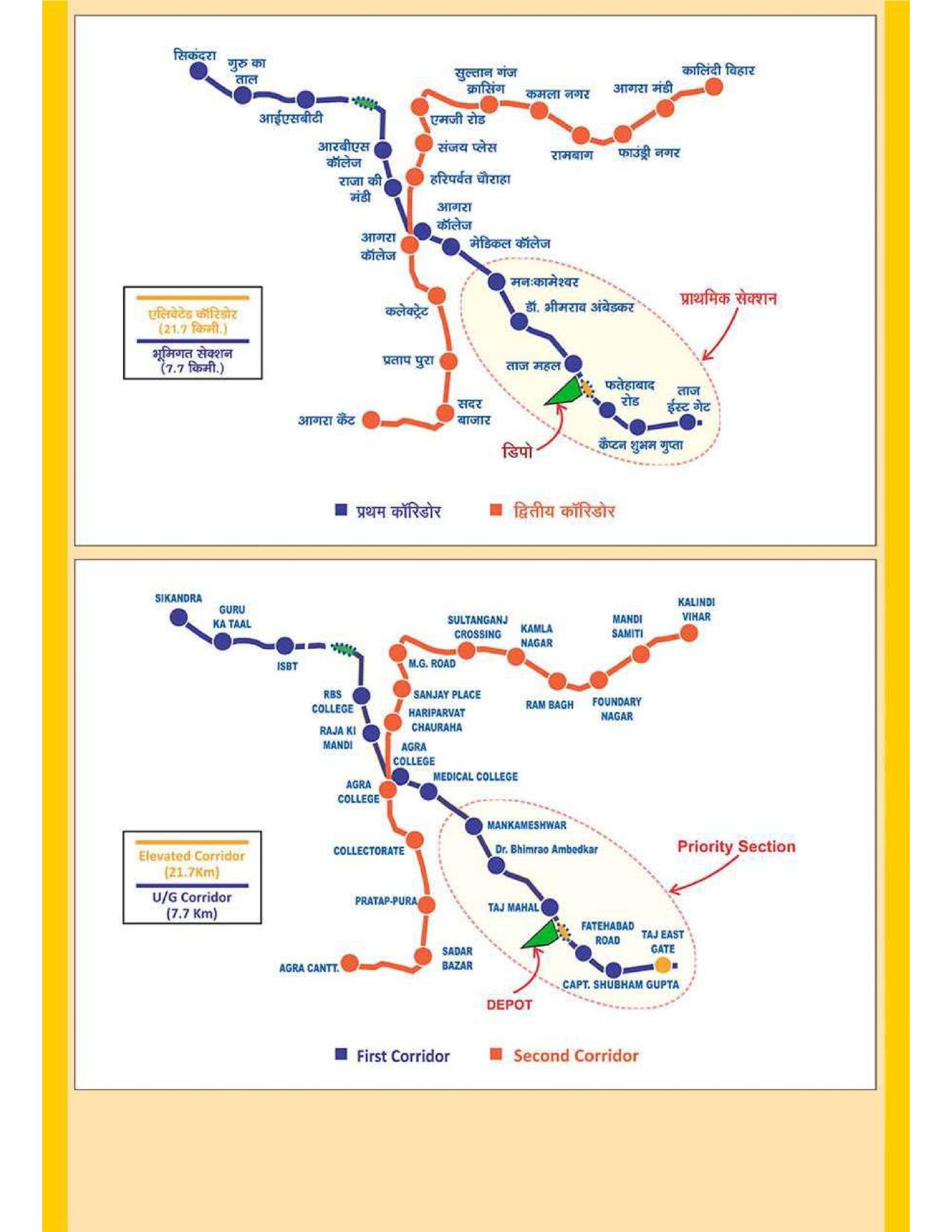
Agra Metro Map 2026: Lines, Tickets & Prices
Last updated: August 20, 2026

Last updated: August 20, 2026
Current metro service updates for Agra
As of August 14, 2026, passenger service runs only between Taj East Gate and Mankameshwar; the remaining Phase 1 stations are not open. Current service information is available from UPMRC.
The Agra Metro route map presents the approved Phase 1 target network and may use individual planning labels. It must not be read as a map of 29.4 km available to passengers today.
Current UPMRC data covers only the 6 km priority section between Taj East Gate and Mankameshwar. Current passenger service and station names are shown in the operating-status table and station list below.
Contents
Agra only began carrying metro passengers on March 6, 2024, and the contrast between its compact operating line and much larger official plan is the key to reading this map.
As of August 14, 2026, the approved Phase 1 project overview spans 29.4 km and 27 stations, but current UPMRC data covers only the six-station operating section from Taj East Gate to Mankameshwar.
Uttar Pradesh Metro Rail Corporation, usually shortened to UPMRC, operates this compact line. The 11-minute end-to-end ride is useful for short trips in central Agra.
Six stations are open, three elevated and three underground. Open stations have elevators and escalators, tactile lines, Braille plates, wider access gates, and staff-assisted wheelchairs.
The official map includes sections that are not available for passenger travel. The operating-status table below distinguishes the open priority section, construction areas, and the approved target network.
The six open Agra Metro stations are listed in travel order. Taj East Gate to Mankameshwar is the complete passenger route shown by current UPMRC data.
Sikandra, Agra Cantt, RBS College, and Kalindi Vihar may appear on the broader plan, but none is part of the six-station passenger section.
| Section or corridor | Status | Stations or limits | What it means for travelers |
|---|---|---|---|
| Line 1 priority section | Open as of August 14, 2026 | Taj East Gate to Mankameshwar; 6 km; 6 stations | This is the complete passenger network in 2026. |
| Corridor 1 balance | Under construction as of August 14, 2026 | Mankameshwar toward ISBT and Sikandra | Test activity does not mean that passenger service is open. |
| Corridor 2 | Under construction as of August 14, 2026 | Agra Cantt to Kalindi Vihar; 15.7 km; 14 elevated stations | Agra Cantt and Kalindi Vihar are not available as metro stops. |
| Phase 1 target network | Approved | Both corridors; 29.4 km; 27 stations | The official plan represents this target network, not only today's route. |
The operating line is practical for the Taj Mahal, Agra Fort, and the old-city area around Mankameshwar and Jama Masjid. Other major sights still require an auto-rickshaw, taxi, bus, or road transfer.
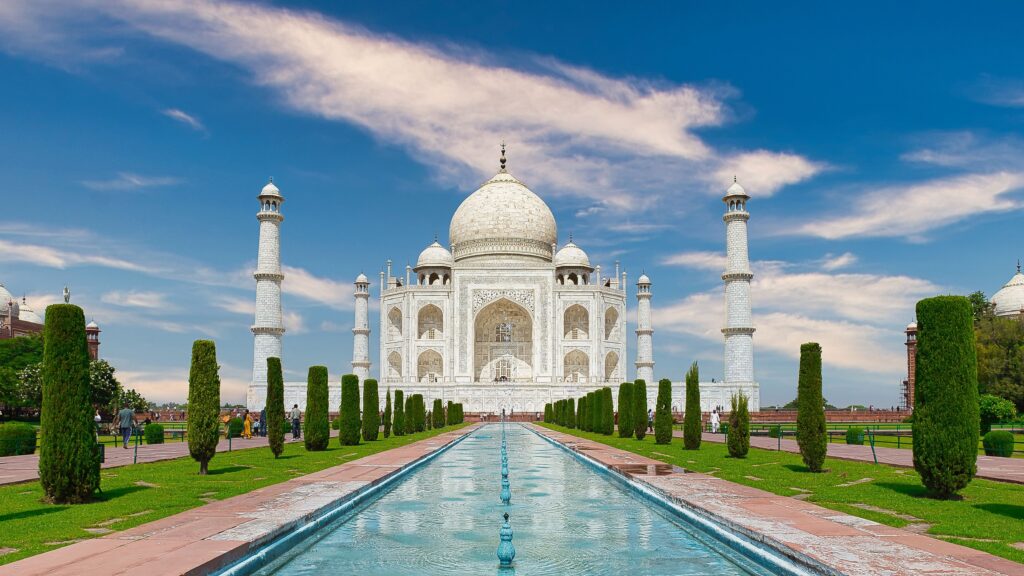
For most Taj Mahal visitors, Taj Mahal Metro is the practical stop. From Gate 1, listed in UPMRC’s station details, the walking route to the West Gate is about 0.7 km and takes roughly 8 to 10 minutes.
Taj East Gate Metro is less convenient than its name suggests. Its Gate 1 is about 2.4 km from the Taj East Gate by the walking route, around 28 to 30 minutes on foot.
The West Gate is the monument’s main entrance, while official visitor guidance recommends the East Gate for avoiding crowds. The Taj Mahal is generally open from 30 minutes before sunrise until 30 minutes before sunset and is closed to general visitors on Fridays.
UPMRC’s station details place Agra Fort Metro Gate 1 at Ram Leela Maidan. The walk to Amar Singh Gate is about 0.6 km, or 8 to 10 minutes.
UPMRC’s station details place Mankameshwar Gate 1 at Bijli Ghar Chauraha. The walk to Jama Masjid is about 0.6 km and takes around eight minutes.
Itmad-ud-Daulah and Mehtab Bagh sit beyond the open metro corridor. From Mankameshwar, the road distances are about 3.4 km and 5.3 km respectively, so an auto-rickshaw or taxi is more practical than walking.
Sikandra has no open station. Akbar’s tomb is about 10 km from the city center and can be reached by city bus, auto-rickshaw, or taxi.
Agra Cantt is outside the operating network. The Taj Mahal is about 6 km from the railway station; onward options include pre-paid taxis, auto-rickshaws, and cycle-rickshaws.
Fatehpur Sikri lies 36 to 40 km west of Agra via NH-21. There is no open metro connection; official access options include UPSRTC buses from ISBT or Idgah and taxis.
| Attraction or destination | Line | Station | Practical note |
|---|---|---|---|
| Taj Mahal | Line 1 | Taj Mahal | The 0.7 km walk to the West Gate takes roughly 8 to 10 minutes. |
| Agra Fort | Line 1 | Agra Fort | The 0.6 km walk to Amar Singh Gate takes roughly 8 to 10 minutes. |
| Mankameshwar and Jama Masjid | Line 1 | Mankameshwar | The 0.6 km walk from Gate 1 to Jama Masjid takes roughly eight minutes. |
| Itmad-ud-Daulah | No open metro line | No open station | About 3.4 km from Mankameshwar by road; an auto-rickshaw or taxi is practical. |
| Mehtab Bagh | No open metro line | No open station | About 5.3 km from Mankameshwar by road; a road transfer is required. |
| Sikandra | No open metro line | No open station | About 10 km from the city center; city buses, auto-rickshaws, and taxis serve the area. |
| Agra Cantt | Corridor 2 under construction | No open station | The Taj Mahal is about 6 km away; pre-paid taxis, auto-rickshaws, and cycle-rickshaws are available. |
| Fatehpur Sikri | No metro corridor | No station | UPSRTC buses from ISBT or Idgah and taxis cover the 36 to 40 km trip west. |
Fares depend on how many station intervals the trip covers. Adjacent stations cost INR 10 (approx. USD 0.10); trips spanning two intervals cost INR 15 (approx. USD 0.16).
Trips spanning three to five intervals cost INR 20 (approx. USD 0.21). Single-journey and group mobile QR tickets are available.
| Ticket | Price | Buy ticket |
|---|---|---|
| Single-journey mobile QR ticket | INR 10 (approx. USD 0.10), INR 15 (approx. USD 0.16), or INR 20 (approx. USD 0.21), depending on origin and destination | Official app developed by UPMRC: Google Play and Apple App Store |
| Group mobile QR ticket | No separate 2026 fare is listed | Official app developed by UPMRC: Google Play and Apple App Store |
Prices as of August 2026; source: operator.
Mobile QR tickets can be purchased in the official app before entering a station. The iOS app accepts debit cards, credit cards, and online banking, and the mobile instructions direct passengers to scan the QR code in the metro station.
Station security checks apply. Without operator approval, one bag may measure up to 80 x 50 x 30 cm and weigh 25 kg; bundles are prohibited.
The first train runs at 6:00 AM and the last train at 10:00 PM. The timetable provides no direction-specific first or last train times for Agra.
The UPMRC timetable gives an end-to-end travel time of 11 minutes from Taj East Gate to Mankameshwar and a peak interval of 5 minutes 48 seconds.
The timetable gives no separate weekend, holiday, off-peak, or late-evening interval. Regular service ends with the 10:00 PM last train; current Timetable information is available from UPMRC.
The systems in Agra and Delhi are separate. There is no metro ride from Delhi to Agra; travelers need an intercity train, bus, or road journey before using local transport.
One current Indian Railways timetable lists Intercity 14212 from New Delhi at 5:35 PM to Agra Cantt at 10:05 PM, a journey of 4 hours 30 minutes. UPMRC’s current service data shows that Agra Cantt itself has no open metro station.
AAI airport transport information lists no metro service for Agra Airport, also called Kheria Airport, and the UPMRC project report does not place the airport on either corridor. AAI aerodrome information places the airport about 10 km west of the city, while Agra District travel information gives a distance of 13 km from the Taj Mahal.
AAI airport transport information lists no formal airport bus, taxi, or rental-car service. A pre-arranged road pickup is therefore the practical option.
As of August 14, 2026, UPMRC’s live station list ended at Mankameshwar. Every other Phase 1 section remained under construction: Corridor 1 toward ISBT and Sikandra, and Corridor 2 between Agra Cantt and Kalindi Vihar.
A contractor update records a 6 km test run from Mankameshwar to ISBT on December 30, 2025. UPMRC’s June 2026 station update still described RBS College as an upcoming station; neither section was open to passengers on August 14, 2026.
UPMRC’s May 2026 construction update records work at a new Yamuna bridge. The 15.7 km Corridor 2 is not open to passengers.
The approved Phase 1 project overview totals 29.4 km and 27 stations across both corridors.
Fun Fact: In a project overview updated on November 20, 2024, UPMRC reported that the 3 km underground priority section had been completed in 18 months, including 11 months from the start of tunnel-boring work.
Yes. Passenger service runs on the 6 km Line 1 priority section between Taj East Gate and Mankameshwar. Service began on March 6, 2024.
There are six open stations: Taj East Gate, Shaheed Captain Shubham Gupta, Fatehabad Road, Taj Mahal, Agra Fort, and Mankameshwar.
The current route runs from Taj East Gate to Mankameshwar. It is the only passenger route on the official plan that is open throughout.
No. As of August 14, 2026, the priority section is open, while the rest of Corridor 1 and all of Corridor 2 remain under construction. The approved Phase 1 plan is a target network, not a fully operating system.
Taj Mahal Metro is the closest practical station. Gate 1 is about 0.7 km from the West Gate, roughly 8 to 10 minutes on foot along the walking route.
The trip is one stop on Line 1 from Agra Fort to Taj Mahal Metro. The normal fare is INR 10 (approx. USD 0.10), followed by about 0.7 km on foot to the West Gate.
Normal fares are INR 10 (approx. USD 0.10), INR 15 (approx. USD 0.16), or INR 20 (approx. USD 0.21), depending on origin and destination.
The normal fare from Taj Mahal Metro to Agra Fort is INR 10 (approx. USD 0.10).
The official UPMRC app sells single-journey and group mobile QR tickets and is available for both Google Play and the Apple App Store.
The first train runs at 6:00 AM and the last train at 10:00 PM. The timetable gives no direction-specific or separate weekend schedule.
No. The two city systems are separate, so travel between them requires an intercity train, bus, or road journey.
No. Agra Airport has no metro station or direct metro journey. AAI lists no formal terminal bus or taxi service, so a pre-arranged road pickup is the practical option for the 13 km trip toward the Taj Mahal area.
You might also be interested in these metro maps – for comparison or for your next trip: