Kyoto Subway Map 2026: Lines, Tickets & Prices
Last updated: August 20, 2026.

Last updated: August 20, 2026.
Kyoto Subway service information
Timetables changed on March 14, 2026. Check the official journey planner for the latest route and departure information before traveling.
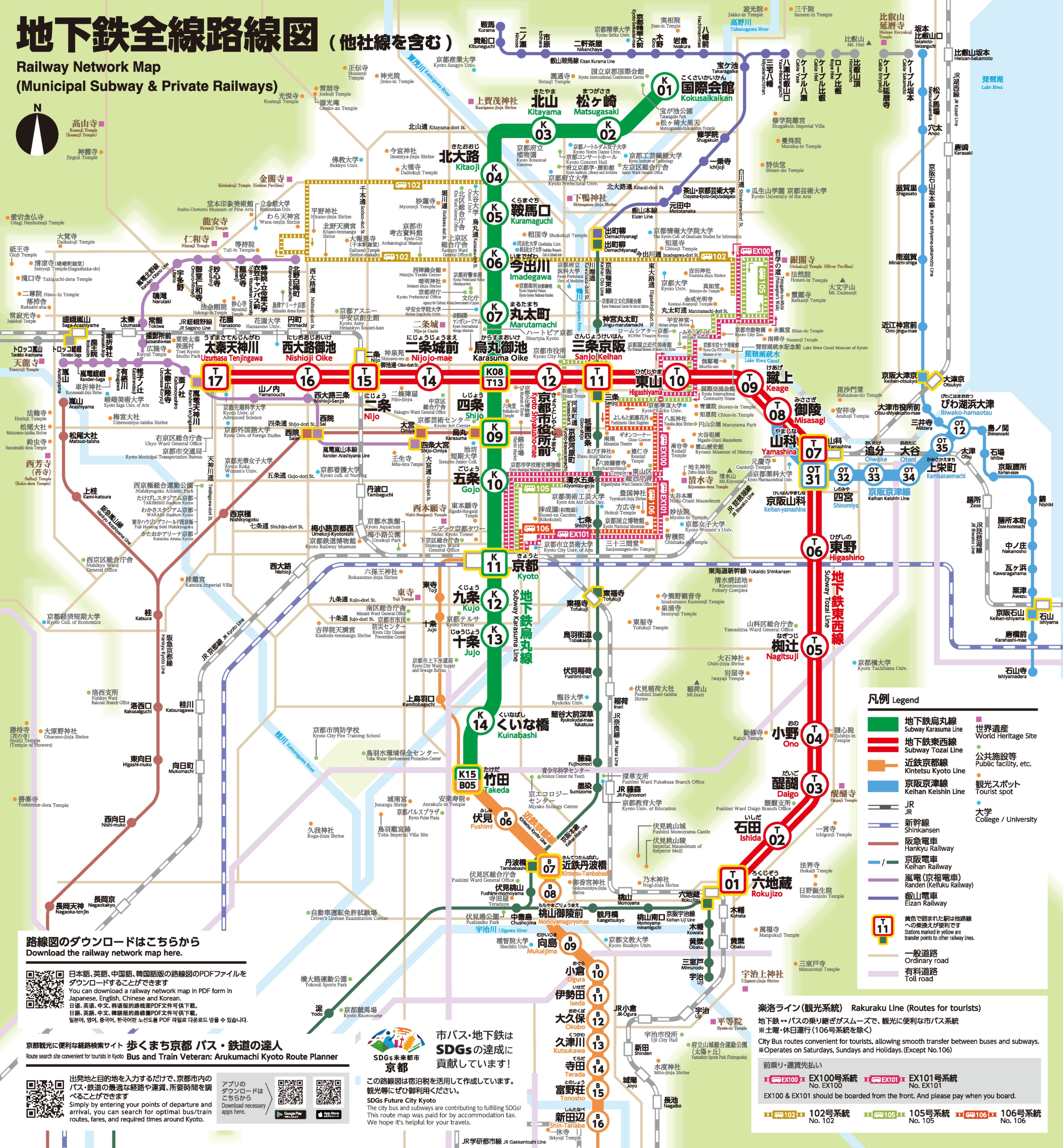
The official English Kyoto subway map is a Railway Network PDF that highlights both Kyoto Municipal Subway lines and also shows connecting private railways. It is separate from the combined Subway & Bus Navi.
A network of only two lines gives Kyoto a compact subway backbone from north to south and east to west. Kyoto City Transportation Bureau operates the officially named Kyoto Municipal Subway.
The first Karasuma Line section, between Kitaoji and Kyoto, opened on May 29, 1981. The present network extends for 31.2 km: 13.7 km on Karasuma and 17.5 km on Tozai.
The two lines list 15 and 17 stations, but Karasuma Oike (K08/T13) belongs to both, so the network has 31 stations.
An end-to-end ride takes about 26 minutes on the Karasuma Line and 34 minutes on the Tozai Line. Both operate at a maximum speed of 75 km/h.
Selected Karasuma trains continue south from Takeda onto Kintetsu tracks toward Shin-Tanabe or Kintetsu-Nara as through services. Not every train continues, and there is no through route to Kintetsu Kyoto Station. Takeda is also the fare boundary.
Selected four-car Keihan Keishin trains enter the Tozai Line at Misasagi and continue toward Kyoto Shiyakusho-mae or Uzumasa Tenjingawa. They do not serve Yamashina or the Rokujizo branch, so passengers for those stations must change at Misasagi.
Kintetsu and Keihan through services do not create extra Kyoto subway lines. Kyoto still has exactly two lines. Kintetsu and Keihan remain separate operators with their own fares and pass rules.
The Kyoto subway is most useful for Kyoto Station, the city center, Nijo Castle, the Imperial Palace, Higashiyama and Daigo. Famous destinations including Fushimi Inari and Kinkaku-ji are not directly served by subway.
Kyoto City’s 2025 tourism survey estimated about 62.8 million visitors. This broad measure includes non-residents arriving for leisure, business, shopping, events, sports, or visits to friends and relatives, while commuting and study trips are excluded.
Kyoto has no public airport. Arrivals from KIX and ITM normally reach Kyoto Station first, where Kyoto K11 on the Karasuma Line provides the municipal subway connection into the city.
| Attraction | Line | Station | Practical note |
|---|---|---|---|
| Nijo Castle | Tozai Line | Nijojo-mae T14 | Direct subway access. |
| Kyoto Imperial Palace | Karasuma Line | Imadegawa K06 | About five minutes on foot. |
| Kyoto Station and station area | Karasuma Line | Kyoto K11 | Main interchange for JR, Kintetsu and buses; change at Karasuma Oike for Tozai. |
| Nishiki Market | Karasuma Line | Shijo K09 | About five minutes on foot. |
| Heian Shrine | Tozai Line | Higashiyama T10 | Continue on foot via Sanjo-dori and Jingu-michi. |
| Daigo-ji | Tozai Line | Daigo T03 | Daigo Station + about 10 minutes on foot. |
| Fushimi Inari | Not served by subway | JR Inari or Keihan Fushimi-inari | Use the separate JR Nara Line or Keihan network. |
| Kinkaku-ji | No direct subway station | Kitaoji K04, then bus | Take bus 204 or 205 to Kinkakuji-michi, then walk about five minutes. |
A Kyoto train map needs more than the two-line municipal diagram. Kyoto’s rail landscape includes the subway, JR and five private or specialist rail networks, each with separate fares and route roles.
JR links Kyoto Station with Fushimi Inari on the Nara Line and Arashiyama on the Sagano or San-in corridor. Hankyu links Osaka-Umeda, Karasuma, Kawaramachi and Arashiyama via Katsura, connecting with the subway at Shijo.
Keihan follows eastern Kyoto toward Osaka and serves Fushimi Inari, with subway connections around Sanjo and Misasagi. Kintetsu serves its own network south of Kyoto and operates selected through trains beyond Takeda.
Randen is a separate tram-style railway toward Arashiyama, connecting with Tozai at Randen-Tenjingawa. Eizan runs two separate lines from Demachiyanagi toward northern excursion areas, while Kyoto City Bus fills many gaps away from rail stations.
The downloadable subway PDF therefore cannot replace a complete Kyoto rail diagram. Through-running trains share some tracks, but JR, Hankyu, Keihan, Kintetsu, Randen and Eizan do not become municipal subway lines.
Kyoto uses distance-based subway fares. Since October 1, 2025, an adult single journey costs ¥220 to ¥360 (≈ $1.38 to $2.26); the corresponding child fare is ¥110 to ¥180 (≈ $0.69 to $1.13).
The Subway 1-Day Pass covers both subway lines for one calendar day. The Subway & Bus 1-Day Pass also covers all City Bus routes and specified sections of Kyoto Bus, Keihan Bus and West Japan JR Bus, but not airport or intercity services.
| Ticket | Price | Buy ticket |
|---|---|---|
| Adult single fare | ¥220 to ¥360 (≈ $1.38 to $2.26) | Available at stations |
| Child single fare | ¥110 to ¥180 (≈ $0.69 to $1.13) | Available at stations |
| Subway 1-Day Pass | Adult ¥800 (≈ $5.03); child ¥400 (≈ $2.51) | Available at stations |
| Subway & Bus 1-Day Pass | Adult ¥1,100 (≈ $6.91); child ¥550 (≈ $3.46) | Available at stations; KANSAI MaaS coupon via Google Play or Apple App Store; registration and physical exchange required |
| ICOCA starter card | ¥2,000 (≈ $12.57), including a ¥500 deposit (≈ $3.14) and ¥1,500 in stored value (≈ $9.43) | Available at stations |
Fares published by the Kyoto City Transportation Bureau; USD values converted at European Central Bank reference rates of August 19, 2026.
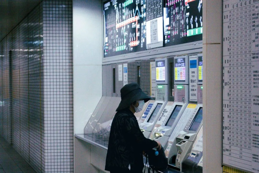
Ticket machines near the gates offer an English interface and take Japanese yen only, not credit or debit cards. A single paper ticket is valid on the purchase day from the station where it was bought and is collected at the exit gate.
Insert a paper ticket or pass into the gate and collect it as you pass through. With an IC card, hold the card on the blue reader for about one second. Load prepaid value before traveling.
The gates accept PiTaPa, ICOCA, Kitaca, PASMO, Suica, manaca, TOICA, HAYAKAKEN, nimoca and SUGOCA, plus Mobile ICOCA and Mobile Suica. The Japan Rail Pass is not valid on the municipal subway.
Do not expect bank-card contactless payment at the fare gate. In 2026, credit-card tapping and QR payment remain unavailable. Kyoto City’s FY2026 budget plan schedules the equipment work for FY2027, when the rollout is planned.
The KANSAI MaaS app is offered by WEST JAPAN RAILWAY COMPANY on Google Play and the Apple App Store. Its combined-pass coupon requires registration and credit-card payment, then exchange for a physical pass before travel; the phone coupon alone does not open the gate.
Kyoto City Transportation Bureau's current timetable took effect on March 14, 2026. First terminal departures are around 5:15 AM to 5:20 AM. Last terminal departures range from 11:28 PM to 11:45 PM, with final trains reaching the opposite terminal between 12:04 AM and 12:19 AM.
Trains generally run every 7 to 8 minutes during the day. Weekday peak gaps are roughly 3 to 6 minutes on Karasuma and 4 to 7 minutes on the base Tozai service.
Weekend mornings are usually less frequent, at roughly 6 to 10 minutes on Karasuma and 7 to 10 minutes on Tozai. Selected Keihan through trains add service on parts of the Tozai Line only; they do not increase the frequency on the Rokujizo branch.
The Kyoto subway map shows the route layout but not departure times. The timetable does not include overnight trains. Travelers planning a late return should check the live journey planner, especially because the last departure depends on direction and station.
The current western end of the Tozai Line at Uzumasa Tenjingawa opened on January 16, 2008. This established the present two-line, 31.2 km network shown in the official English Railway Network PDF.
According to Kyoto City Transportation Bureau, the Tozai Line uses automatic train operation, but one-person crews remain on board. It has platform barriers at all 17 stations. As of February 2026 the Karasuma Line is still manually driven and has platform barriers at four of its 15 stations.
Fun Fact: A Keihan train can enter the Tozai Line at Misasagi and continue through central Kyoto, yet it remains a Keihan service rather than becoming a third subway line.
Use the PDF Download button to open the official English Railway Network PDF published by Kyoto City Transportation Bureau. It is separate from the combined Subway & Bus Navi.
In Kyoto, buy a paper ticket with yen at an English-language machine, use a paper day pass, or tap a compatible transit IC card. Bank-card tapping and QR payment are not available at municipal subway gates in 2026.
The Kyoto Subway 1-Day Pass costs ¥800 for an adult (≈ $5.03) and ¥400 for a child (≈ $2.51). It covers both municipal lines on the calendar day of use, not for 24 hours.
Kyoto’s two municipal subway lines are the green Karasuma Line from Kokusaikaikan to Takeda and the vermilion Tozai Line from Rokujizo to Uzumasa Tenjingawa. They intersect at Karasuma Oike.
From Kansai International Airport, the direct JR-WEST HARUKA reaches Kyoto Station in about 75 to 80 minutes; the tourist one-way ticket costs ¥2,200 for adults (≈ $13.83) and is separate from subway fares. From Osaka Itami Airport, the limousine bus reaches Kyoto Station Hachijo Exit in about 50 to 55 minutes and costs ¥1,500 for adults (≈ $9.43). At Kyoto Station, join the Karasuma Line at Kyoto K11.
Yes. Kyoto Municipal Subway is the system's official English name. Searches for a Kyoto metro map refer to this network, which has exactly two lines and 31 unique stations.
You might also be interested in these metro maps – for comparison or for your next trip: