Philadelphia Subway Map 2026 (SEPTA): Lines & Fares
Last updated: July 19, 2026

Last updated: July 19, 2026
Current service disruptions
Check current service alerts before travel. L, B and elevator conditions can change during the day.
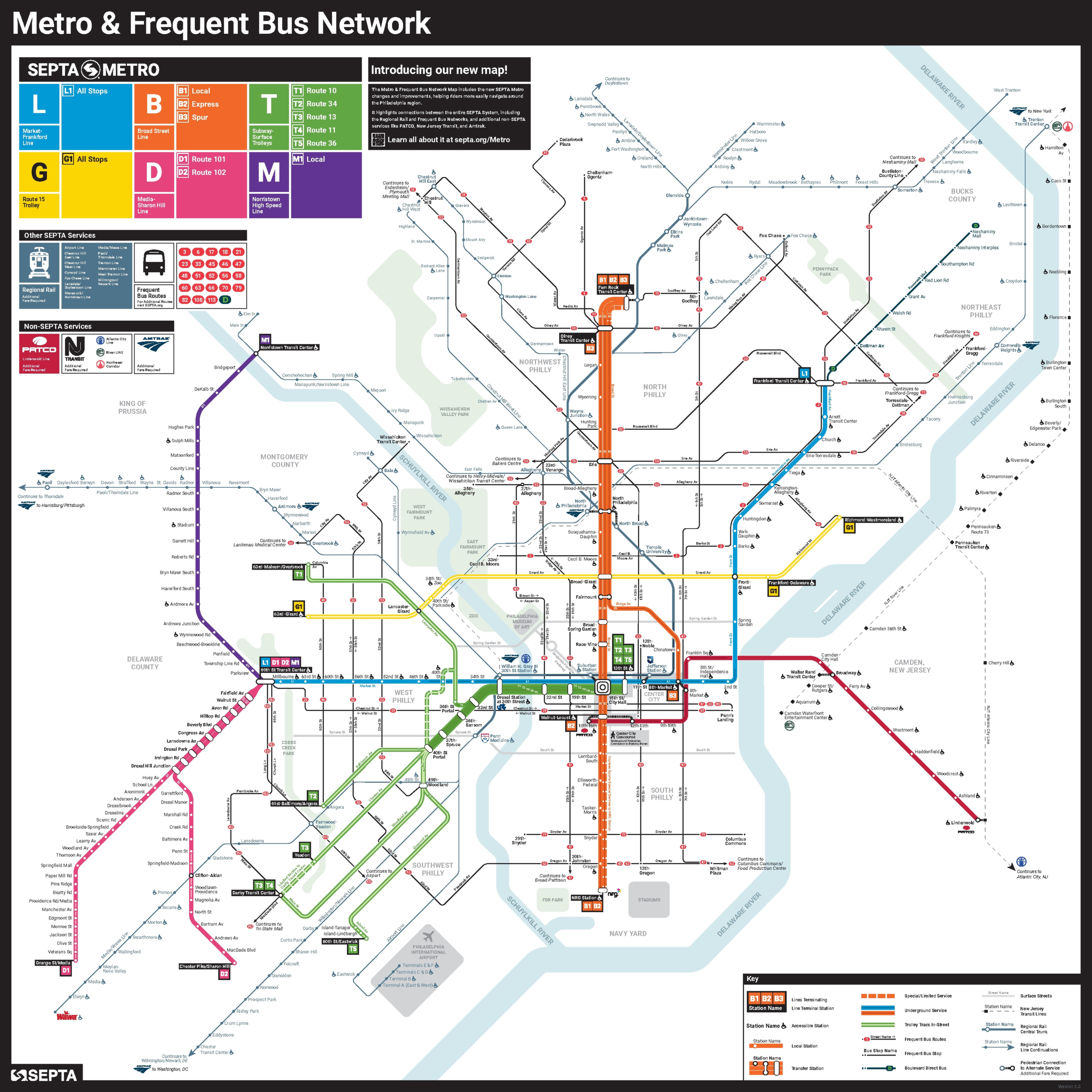
The Philadelphia subway map gives visitors a clear view of the two subway routes: the blue L and the orange B. This guide explains their stations, fares, schedules and connections without counting Regional Rail, trolleys, buses or PATCO as subway lines.
A SEPTA map also shows Regional Rail, trolleys, buses and other Metro services, but Philadelphia’s subway core consists only of the L and B.
Contents
Philadelphia has an unusual two-line subway core within a much larger public-transport network. The Southeastern Pennsylvania Transportation Authority, known as SEPTA, operates the L and B as the city’s subway services, while its broader SEPTA Metro brand also covers the T, G, D and M.
SEPTA’s L history identifies the east-west route as the former Market-Frankford Line, still locally called the El. Its first section opened between 69th Street and City Hall on March 4, 1907. The complete route now covers 13.5 miles and 28 stations.
SEPTA’s Broad Street history identifies the north-south B as the former Broad Street Line. Its original City Hall to Olney section began service on September 1, 1928. The trunk from Fern Rock to NRG covers 10 miles and has 22 stations.
SEPTA’s current B route map shows the B3 Broad-Ridge Spur adding Chinatown and 8th-Market as two unique nodes beyond the trunk count. This produces 24 distinct B nodes, but B3 remains a limited weekday service variant rather than a third Philadelphia subway line.
SEPTA’s May FY2026 ridership report recorded 3.3 million unlinked L passenger trips and 3.2 million unlinked B passenger trips. Those figures apply only to L and B, not to the wider network.
Regional Rail, trolleys and buses connect with the subway but remain separate modes. PATCO also connects in Center City, yet it is a separate DRPA system with its own fares and gates.
The best SEPTA map depends on the trip. The June 2026 system version gives the broadest overview, while the individual L and B route diagrams make station order and service patterns easier to read.
Visitors who need street orientation should use the Center City Transit and Street edition, version 06.2026. The live display is better for checking vehicles and trip details, but it does not replace a stable SEPTA subway map for advance planning.
| Map | Best for | Limitation |
|---|---|---|
| Metro and Frequent Bus Network Map v2.3 | Planning connections across the city with streets and landmarks | Covers more than the L and B scope and includes frequent buses and external connections |
| Metro Route L map v1.5 | Reading all 28 L stations from 69th St to Frankford | Does not show the full B route in equal detail |
| Metro Route B map v1.4 | Distinguishing B1 Local, B2 event express and B3 limited service | Does not provide a complete citywide overview |
| Center City Transit and Street Map 06.2026 | Matching central stations to nearby streets and destinations | Focuses on central Philadelphia rather than both complete routes |
| Real Time System Map | Viewing current vehicles, stops and live trip details | Live information can change and is less suitable as a fixed trip reference |
The main SEPTA map uses the broad June 2026 network version because it combines L, B, central streets and connections. For full station order or the B1, B2 and B3 pattern, use the dedicated route diagrams.
The L and B serve many central visitor destinations, but the right route depends on the exact station, walking distance and accessibility needs. Visit Philadelphia reports that the city welcomed 26.6 million visitors in 2024. The destination matrix below pairs major attractions with useful L or B stops.
The L is the practical east-west route for Old City, Reading Terminal Market and University City. The B runs north-south through City Hall, the Avenue of the Arts, East Passyunk and the stadium district.
Accessible stations carry a wheelchair symbol on official diagrams and schedules. That symbol should not be read as proof that every transfer is step-free. At 15th St/City Hall, the L platforms are accessible, but the route diagram warns that elevator access to connecting services is not available.
The South Broad Concourse between 15th St/City Hall and Walnut-Locust reopened on June 2, 2026 and is intended to remain open. Check the daily elevator status before relying on a specific lift or transfer path.
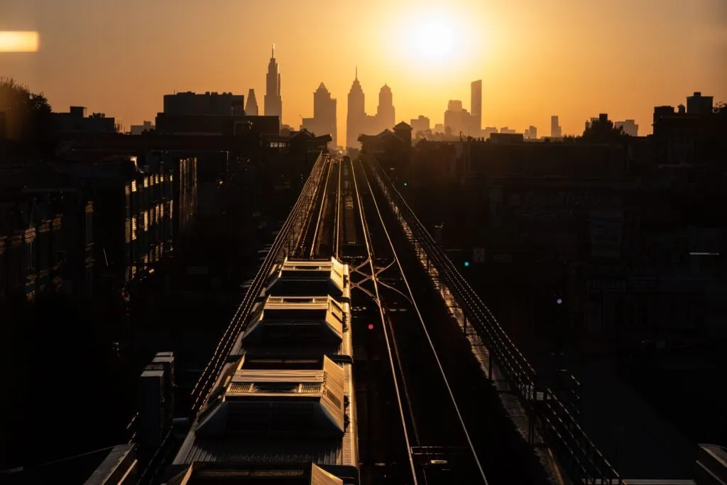
An L train travels toward the Philadelphia skyline on the elevated Market-Frankford Line.
The Center City Transit and Street version is the best answer for travelers seeking a Philadelphia subway map with streets. It adds the street grid and central destinations, while the L and B route diagrams offer clearer station-by-station detail.
A route-specific SEPTA subway map is the safer reference when B1, B2 or B3 service patterns affect the journey.
| Attraction | Line | Station | Note |
|---|---|---|---|
| Independence Hall and Liberty Bell | L | 5th St/Independence Hall | The Independence Visitor Center is only steps from the station; the security entrance at 5th and Chestnut has an accessibility ramp |
| Delaware River Waterfront and Penn's Landing | L | 2nd St | Continue on foot toward the waterfront |
| Reading Terminal Market | L | 11th St | Walk one block west and one block north |
| Dilworth Park and City Hall | L or B | 15th St/City Hall | Both lines serve the central complex; verify elevator paths before transferring |
| Sports Complex | B | NRG | Allow about 10 minutes to walk from the terminal to the complex |
| East Passyunk and the Singing Fountain | B | Tasker-Morris | Walk about two to three blocks |
| Ensemble Arts and Kimmel Cultural Campus | B | Walnut-Locust | The campus is only steps from the station |
| University City and Drexel | L | Drexel Station at 30th St | This stop provides the L connection near Gray 30th Street Station |
SEPTA’s current fare information lists a flat Bus and Metro fare rather than zones on L and B. As of July 19, 2026, one ride costs $2.90 with contactless payment, SEPTA Key Travel Wallet or Quick Trip.
SEPTA’s official payment guide also lists a One Day Convenience Pass for $7.50 with up to eight Bus or Metro trips, or a Three Day Convenience Pass for $19.00 with up to 24 trips within 72 hours. These passes do not include Regional Rail.
| Ticket | Price | Buy ticket |
|---|---|---|
| Contactless bank card or mobile wallet | $2.90 per ride | At the turnstile |
| SEPTA Key Travel Wallet | $2.90 per ride plus $4.95 for the card | Official payment options |
| Quick Trip | $2.90 for one L or B ride | At fare kiosks in all L and B stations |
| One Day Convenience Pass | $7.50 for up to 8 Bus or Metro trips | Official payment options |
| Three Day Convenience Pass | $19.00 for up to 24 Bus or Metro trips in 72 hours | Official payment options |
| SEPTA app for Key management | App download is free; fares are separate | iOS and Android |
For the simplest visit, tap the same contactless credit card, debit card, Apple Pay, Google Pay or Samsung Pay at each turnstile. The $2.90 payment includes up to two free Bus or Metro transfers within two hours when the same medium is used.
Fare kiosks at every L and B station sell SEPTA Key cards and Quick Trips. A Key card costs $4.95, and that fee can be credited after registration within 30 days, with a limit of two card-fee credits per account.
Load or check a Key card at a kiosk, on septakey.org or through the official SEPTA app. The verified iOS and Android listings identify the Southeastern Pennsylvania Transportation Authority as the developer or seller. The app is not called SEPTA Key.
Quick Trip covers one L or B journey on the purchase day until 2:00 a.m. the next morning and includes no free transfers. Enter by tapping or swiping at the turnstile; no tap is required when leaving the Metro.
March 1, 2026 was the last day to buy Key Tix; sales ended March 2. Existing tickets remain valid only through August 28, 2026, with no refunds.
SEPTA’s current L and B schedules took effect on February 22, 2026. The L timetable lists first departures at 4:45 a.m. toward Frankford and 4:36 a.m. toward 69th Street. The last are 12:11 a.m. and 11:59 p.m. respectively.
The B timetable lists first departures at 4:40 a.m. toward NRG and 4:51 a.m. toward Fern Rock. The final listed trains leave at 12:04 a.m. and 12:15 a.m. Some very early L departures operate as express trips and skip stops, so check the station-specific schedule.
The official L timetable lists service every 6 minutes or less across a long weekday daytime band. Weekend daytime gaps are generally no more than 10 minutes, then up to 12 minutes in the evening and 15 minutes late at night.
The official B timetable lists Local service every 8 minutes or less during the main weekday period. On Saturdays, Sundays and holidays, daytime gaps are generally no more than 10 minutes, while early and late service can stretch to 20 minutes.
After regular trains finish, both official schedule PDFs show late-night replacement buses every 15 minutes or less. The live L Owl and B Owl listings expressly apply Sunday through Thursday. Do not assume all-night trains on Friday or Saturday without a current official notice.
Use the current L timetable and current B timetable before travel. Special-event B2 trains and overnight event services operate only when SEPTA announces them.
The 2025 funding crisis briefly reduced Bus and Metro service by 20 percent from August 24 through September 13. Full service returned on September 14, 2025, and the FY2027 budget adopted in June 2026 announced no new fare or service change. The proposed 9:00 p.m. rail shutdown was not implemented.
SEPTA’s letter-based system makes L and B easier to identify across signs, schedules and announcements. The terminology changed, but the two subway routes themselves remain the former Market-Frankford and Broad Street lines.
The SEPTA map includes additional services, but travelers looking for subway service should focus on L and B.
SEPTA began introducing the unified Metro terminology in February 2025 and continued the letter naming in the spring 2026 schedule change. L corresponds to Market-Frankford, while B corresponds to Broad Street.
The alleged new subway line is therefore usually a naming misunderstanding. L and B are new identifiers for existing routes, not proof that a new rapid-transit line opened. B1, B2 and B3 identify local, event-express and Broad-Ridge Spur service patterns within B.
A Philadelphia Metro map can show the wider Metro family, including T, G, D and M. For subway trips, SEPTA’s 2026 visitor guidance identifies only L and B as subway services.
Philadelphia International Airport has no direct L or B station. SEPTA’s current Airport Line timetable identifies the service as Regional Rail, not subway service, and lists trains about every 30 minutes from roughly 5:00 a.m. until midnight.
For L, take the Airport Line to Jefferson Station and walk to 11th St, or use Gray 30th Street for the nearby Drexel Station at 30th St. For B, use Suburban Station and connect at 15th St/City Hall.
The scheduled Airport Line ride to a Center City transfer takes about 19 to 33 minutes depending on the terminal and station. A clear visitor estimate is about 20 to 35 minutes before walking and changing to L or B.
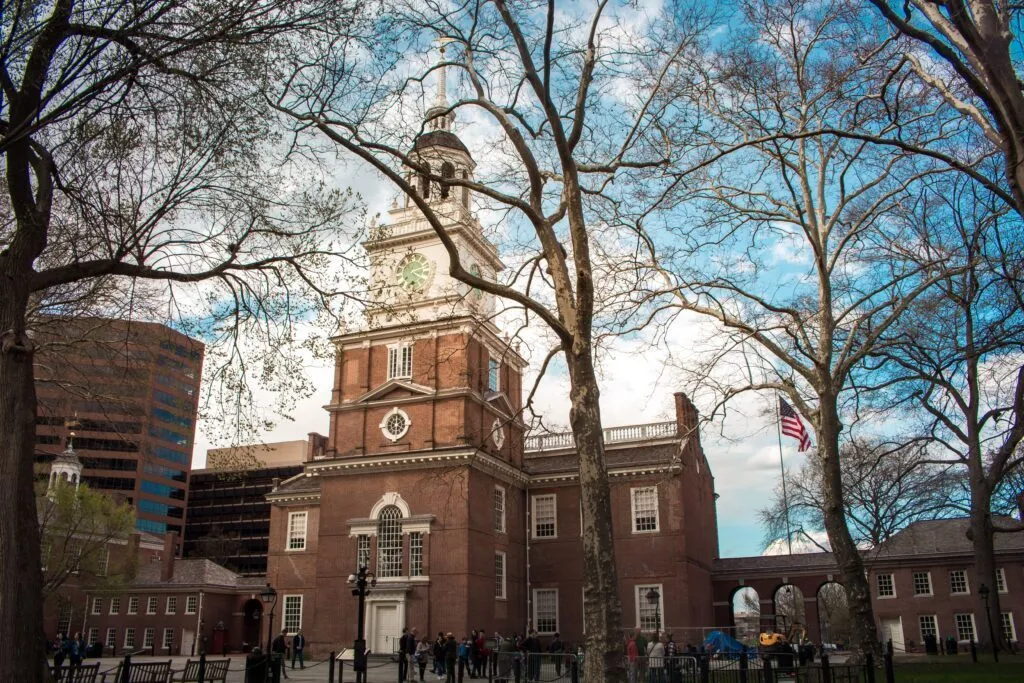
Independence Hall is served by the L at 5th St/Independence Hall.
SEPTA renamed 5th Street as 5th Street/Independence Hall in 2016, placing the destination directly in the station name. This wayfinding decision still helps visitors match Old City landmarks to the correct L stop.
SEPTA’s Airport Line fare between Philadelphia International Airport and Center City is $8.75 at all times with SEPTA Key, contactless payment or a Quick Trip. An inbound ticket bought on board costs $11.00. SEPTA’s general Zone 4 weekend table shows $8.00, but the Airport-specific fare table expressly applies at all times. A later L or B ride requires a separate fare.
PATCO is a separate DRPA-operated railway from Lindenwold into Philadelphia, with its own fare system and gates. It connects with L at 8th & Market. Its 12th/13th & Locust station is about two blocks west of the B at Walnut-Locust.
Fun Fact: The elevated western section of the L offers a moving view of “A Love Letter for You,” a series of 50 rooftop murals. Mural Arts describes the Market/Frankford El as the best place to see the artwork.
Yes. Philadelphia’s subway core consists of the east-west L, formerly the Market-Frankford Line, and the north-south B, formerly the Broad Street Line. Other SEPTA modes connect with them but are not counted as subway lines here.
Yes. A Philadelphia Metro map can include L, B, T, G, D and M under the broader SEPTA Metro brand. SEPTA’s 2026 visitor guidance identifies only L and B as subway services, so travelers should focus on those two lines for subway trips.
Tap a contactless bank card or mobile wallet, or use SEPTA Key Travel Wallet or a Quick Trip. The base fare is $2.90. Contactless and Key include two free Bus or Metro transfers within 120 minutes when you keep using the same medium.
Use a SEPTA map to match east-west trips with L for Old City, Reading Terminal Market and University City. Use B for City Hall, the Avenue of the Arts, East Passyunk and the stadium district. Other destinations may require another mode or a walk.
The letters are new identifiers, not newly constructed routes. L is the former Market-Frankford Line and B is the former Broad Street Line. B1, B2 and B3 are service patterns within B, not three separate subway lines.
Use the full-width viewer and PDF Download button at the top of this page. The locally hosted SEPTA subway map contains official network version 2.3 from June 2026.
Yes. The Center City Transit and Street version 06.2026 combines central transit routes with the street grid. Use the individual L and B diagrams when station order and service patterns matter more than street context.
Take the Airport Line Regional Rail service, not a subway train. For L, change near Jefferson at 11th St or near Gray 30th at Drexel Station. For B, change near Suburban at 15th St/City Hall. Rail time to Center City is about 20 to 35 minutes, and the subsequent subway ride needs a separate fare.
SEPTA stands for Southeastern Pennsylvania Transportation Authority. It operates Philadelphia’s L and B subway services as well as Regional Rail, trolleys and buses.
You might also be interested in these metro maps – for comparison or for your next trip: