Chicago Subway Map 2026: Lines, Tickets & Fares
Last updated: October 21, 2026

Last updated: October 21, 2026
Current service alerts
The elevated State/Lake station is closed for reconstruction. Outside the scheduled elevated Loop suspension, use Clark/Lake or Washington/Wabash as alternatives. Lake Street Bridge work interrupts Green Line service between Clinton and Clark/Lake; shuttle buses connect the stations. This disruption is expected to last until 4:00 AM on October 26, 2026. The Pink Line runs via Racine to the Blue Line instead of entering the Loop. From 4:00 AM on October 24 to 2:00 AM on October 26, 2026, elevated Loop service is suspended, including Washington/Wabash, Adams/Wabash and Quincy. During that period, check current CTA service alerts for shuttle buses and the unaffected downtown Red and Blue subway services.
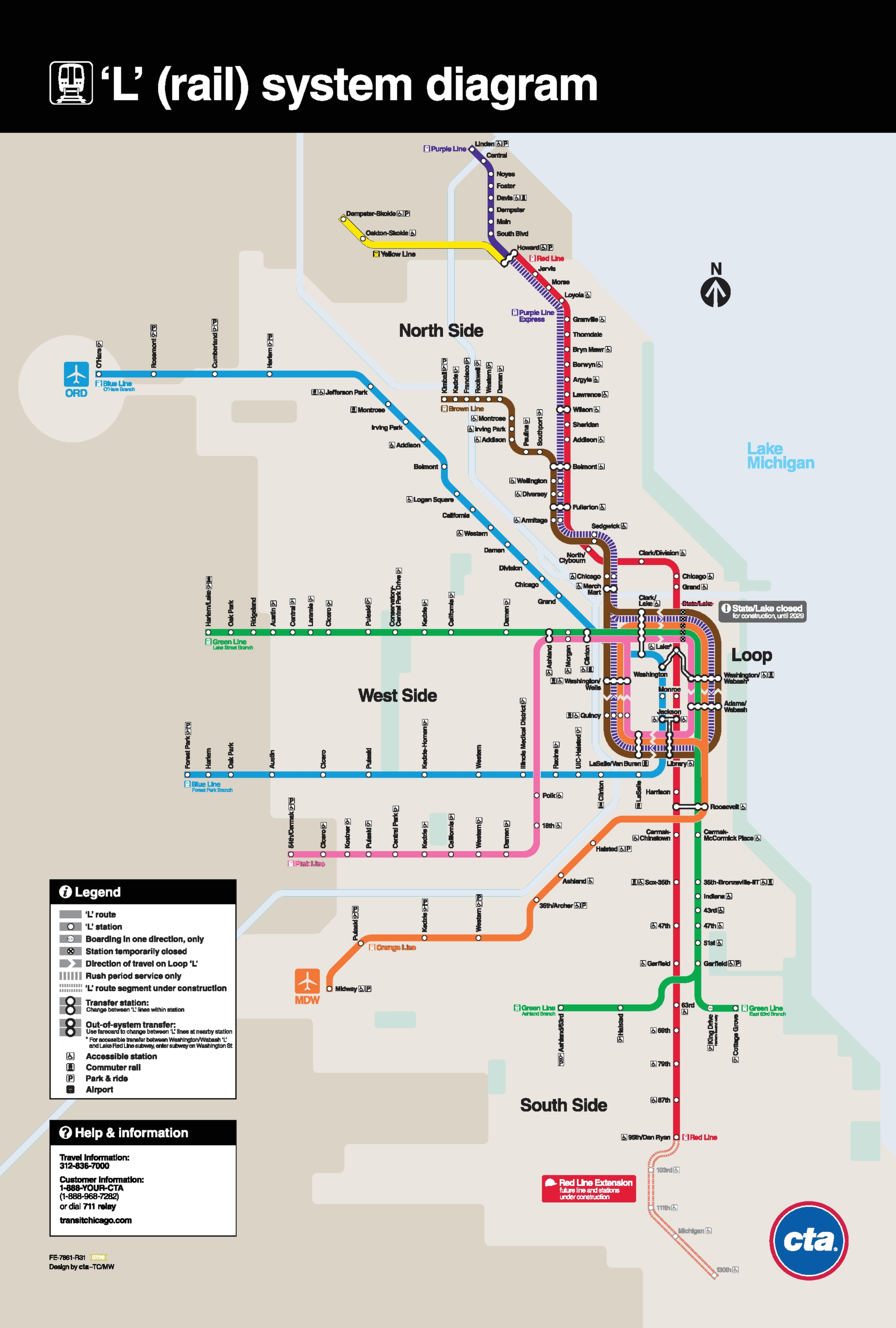
The Chicago Subway Map shows the CTA ’L’ system map, edition R31 (July 2026), with eight color-coded lines. Lawrence, Argyle, Berwyn and Bryn Mawr are open again; the map marks State/Lake as closed for construction until 2029. This Chicago train network includes subway tunnels on the Red and Blue Lines, elevated tracks and ground-level sections. You can view and download the PDF above. Below, you will find stations for major sights, current fares, airport journeys and schedules.
Contents
Chicago’s first rapid transit railroad began operating on June 6, 1892. The Chicago Transit Authority, or CTA, has operated since 1947. Its “L” metro network combines elevated tracks, subway tunnels and ground-level sections. For another historic US rapid transit system, see the Boston Subway Map.
According to the CTA, eight rail lines serve 146 stations. It reported 138.4 million “L” rides in 2025. The CTA’s figure of 224.1 track miles equals about 360.7 track kilometers; track length is a different measure from route length. The eight color-named metro lines and station locations matter more when planning a journey.
The Loop is an elevated rail circuit downtown. Brown, Green, Orange and Pink Line trains serve its stations, while Purple Express trains join them during weekday rush hours. The Red and Blue metro lines use downtown subway tunnels. Each Loop line has its own stopping pattern, so check the station as well as the line.
On the Chicago Metro Map, you can identify “L” train lines by their colors rather than numbers. The Loop links many downtown destinations, but some metro destinations lie beyond the elevated tracks. Check both the line and the station in the destination table, along with any final walk or bus connection.
The Red Line from Howard to 95th/Dan Ryan and the Blue Line from O’Hare to Forest Park run around the clock. South of downtown, the Green Line branches toward Cottage Grove and Ashland/63rd. On the Purple Line, distinguish the local Linden to Howard service from the limited weekday rush hour express into the Loop. If you are looking for a Chicago Red Line Map, follow the solid red route on the PDF to its current southern terminus at 95th/Dan Ryan.
The eight “L” lines use the color names Red, Blue, Brown, Green, Orange, Pink, Purple and Yellow. You will see the same names in CTA schedules. These are the regular metro routes; construction can temporarily interrupt a section. Check the latest CTA alert for your trip, especially around the Loop.
Chicago recorded about 56.8 million domestic and international visits in 2025. Lake Michigan, the downtown high rises and attractions north and south of the Loop span several metro and train lines. The “L” often brings you close to a sight, although some destinations require a short walk or bus ride.
For Millennium Park and the Art Institute of Chicago, take the Brown Line to Washington/Wabash and Adams/Wabash respectively. These metro stops appear on the Chicago Metro Map; walk the final blocks to the entrances. For Willis Tower, use Quincy. For Wrigley Field, ride the Red Line to Addison. The table also shows final walks and bus transfers.
| Sight/Place | Line | Station | Tip |
|---|---|---|---|
| Millennium Park | Brown Line | Washington/Wabash | Walk two blocks east |
| Art Institute of Chicago | Brown Line | Adams/Wabash | Walk one block east |
| Willis Tower/Skydeck | Brown Line | Quincy | Walk one block west |
| Navy Pier | Red Line | Grand | Transfer to bus #29 or #65; no direct “L” station |
| Wrigley Field | Red Line | Addison | Walk about half a block to the stadium |
| Chinatown | Red Line | Cermak-Chinatown | Direct access to the neighborhood |
| Soldier Field | Red Line | Roosevelt | About 15 minutes on foot or take a bus |
| Field Museum/Museum Campus | Red Line | Roosevelt | Transfer to bus #146 for Museum Campus |
Navy Pier has no “L” station. Take the Red Line to Grand, then transfer to bus #29 or #65 toward the pier. For Soldier Field, you can walk about 15 minutes from Roosevelt station. To reach the Field Museum, bus #146 connects Roosevelt with Museum Campus.
The station choices in the table apply during normal service. State/Lake remains closed for reconstruction; outside the scheduled elevated Loop suspension, Clark/Lake or Washington/Wabash can be used as alternatives. From 4:00 AM on October 24 to 2:00 AM on October 26, 2026, elevated Loop service is suspended, including Washington/Wabash, Adams/Wabash and Quincy. Check CTA diversions for that period before setting out.
The Chicago Subway Map, also sought as the Chicago Metro Map, shows the Blue Line reaching the airport. At O’Hare Airport, its O’Hare station sits in the lower level walkway serving Terminals 1 through 3. From Terminal 5, first take the free Airport Transit System train. CTA gives 40 to 45 minutes for the metro ride downtown, and Blue Line trains run all night.
At Midway Airport, a covered walkway leads to the Orange Line station named Midway. Trains reach the Loop in about 20 to 25 minutes. Orange Line service does not run all night; CTA lists bus N62 for late trips. The higher O’Hare fare applies when boarding there, while the regular “L” fare applies from Midway.
The Chicago subway uses a flat base fare rather than distance-based pricing. Boarding at O’Hare costs more. A regular “L” ride paid with Ventra value or a contactless bank card costs $2.50; a separate single ride paper ticket from a machine costs $3.00. The fare depends on how you pay and where you board, so the two ticket types should not be confused.
For repeated trips on the Chicago metro, 1-, 3-, 7- and 30-day passes are available. From first use, they allow unlimited rides on CTA trains and buses and regular Pace buses for the pass period. They do not generally include Metra. Reduced fares apply to specific rides and the 30-day pass for eligible riders, subject to the relevant program and proof of eligibility.
| Ticket | Price | Buy ticket |
|---|---|---|
| Regular “L” ride with Ventra or contactless payment | $2.50 | Available on site |
| Single ride paper ticket | $3.00 | Available on site |
| Reduced “L” ride, with eligibility | $1.25 | Available on site |
| Student ride with Student Ventra Card | $0.75 | Available on site |
| 1-day pass | $5.00 | Google Play / Apple App Store |
| 3-day pass | $15.00 | Google Play / Apple App Store |
| 7-day pass | $20.00 | Google Play / Apple App Store |
| 30-day pass | $75.00 | Google Play / Apple App Store |
| Reduced 30-day pass, with eligibility | $35.00 | Available on site |
| Boarding at O'Hare, regular fare | $5.00 | Available on site |
| Boarding at O'Hare, reduced fare | $1.25 | Available on site |
Ventra vending machines stand in CTA “L” stations before the platform entrance. They sell Ventra Cards as well as single ride paper tickets and day passes. For metro travel, a new Ventra Card initially costs $5.00; Ventra credits that amount as transit value if you register the card in time. You can then add transit value or a pass to the card.
Tap your Ventra Card, contactless bank card or phone wallet at the reader before entering the train platform. A standard fare includes up to two additional rides within two hours at no extra charge. Use the same payment method each time to receive the transfer benefit. A cash bus fare does not include it.
Through the Ventra app, you can load CTA/Pace transit value and passes onto a Ventra Card. Single Metra tickets bought directly in the app are for Metra. You can also buy a Regional Day Pass for CTA, Metra and Pace together with a Metra Day Pass; the CTA/Pace portion is used on a registered Ventra Card.
Children aged 7 to 11, eligible school students and riders aged 65 or older may qualify for specified reduced fares. Children aged six or younger ride free with a paying adult. College students do not receive a general discount; the U-Pass program applies at participating institutions. Have the required eligibility card or proof for any reduced fare.
Red and Blue Line trains run 24 hours every day. Other metro lines have different service windows depending on direction and starting station. Brown Line trains leave Kimball toward the Loop from 4:00 AM to 1:30 AM Monday through Saturday and from 5:00 AM to 1:00 AM on Sundays and holidays. Those are departure windows at Kimball, not promised times at every stop.
On the Green Line, trains leave Harlem/Lake for Cottage Grove from 3:45 AM to 12:45 AM on weekdays; on Saturdays and Sundays, this service starts at 4:45 AM. Times toward Ashland/63rd differ. Yellow Line trains leave Dempster-Skokie for Howard from 4:55 AM to 11:15 PM on weekdays, with weekend service starting at 6:30 AM.
A station example shows why no single train frequency covers the whole Chicago metro. From Armitage toward the Loop, Brown Line trains depart roughly every 4 to 8 minutes on weekday mornings, every 6 to 8 minutes at midday and every 7 to 15 minutes in the evening. Construction can change the interval on a particular travel day.
For the Green Line from Clark/Lake toward Harlem/Lake, the CTA schedule shows trains every 8 to 10 minutes on weekday mornings and afternoons and about every 10 minutes at midday. These figures apply to that station, direction and day type; other stops can differ. Check the actual departure for a late trip.
Red Line, Orange Line, Yellow Line, Green Line, Blue Line, Purple Line, Brown Line, Pink Line
The Chicago Metro Map shows the Red and Blue Lines as round-the-clock rail routes. CTA supplements these metro routes with Night Owl buses. Night routes display an N before the number, such as N4. Many Owl buses run approximately every 30 minutes, though the exact departure depends on the route and stop.
For travel between the airport and downtown, Blue Line trains from O’Hare also run overnight. Orange Line trains from Midway do not run continuously; CTA lists bus N62 for nighttime trips. Allow time to walk from the terminal to the station if you are trying to catch a final train, and check that day’s schedule.
The Red Line Extension has been under construction since its April 2026 groundbreaking. Plans extend the line from 95th/Dan Ryan to 130th Street, with new stations at 103rd, 111th, Michigan and 130th. CTA targets 2030 for opening; these stops are not in service yet. The map shows the Red Line Extension beyond 95th/Dan Ryan as a dashed future line under construction, not as a route in service.
Under the Red and Purple Modernization Project, Lawrence, Argyle, Berwyn and Bryn Mawr stations reopened in July 2025. The Green Line’s Damen station opened in August 2024, and Austin reopened after reconstruction in August 2026. Further RPM phases are being planned without a confirmed opening date.
The elevated railway in the Loop is part of Chicago’s streetscape. Compare its layout with the Paris Metro Map, the New York Subway Map and the Berlin Metro Map. Their networks have different shapes; in Chicago, the line colors and Loop remain the key points of orientation.
Fun Fact: CTA identifies The Blues Brothers as a film featuring its classic “L” car design. The movie offers a glimpse of Chicago’s elevated trains as part of the city’s cultural identity.
To reach O’Hare Airport, take the Blue Line to O’Hare station; the ride from downtown takes 40 to 45 minutes. From Midway station, the Orange Line reaches the Loop in 20 to 25 minutes. A regular ride boarding at O’Hare costs $5.00, while the regular fare from Midway is $2.50.
A regular ride with Ventra value or contactless payment costs $2.50. A single ride paper ticket costs $3.00. The special regular fare when boarding at O’Hare is $5.00; a valid period pass avoids that surcharge.
The “L” includes elevated tracks, subway tunnels and ground-level sections. The Red and Blue Lines run through downtown tunnels, while several other lines serve elevated Loop stations. “L” is the proper name of CTA’s rail system and does not mean every section is elevated.
The Chicago Transit Authority operates eight color-named lines: Red, Blue, Brown, Green, Orange, Pink, Purple and Yellow. Red and Blue Line trains run 24 hours a day. Night Owl buses supplement rail service on several routes; other train lines have their own service hours.
CTA offers 1-, 3-, 7- and 30-day passes for unlimited rides on CTA services and regular Pace buses. A 1-day pass costs $5.00 and a 3-day pass costs $15.00. You can load value or passes onto Ventra or tap a contactless payment method at the fare gate.
For Navy Pier, take the Red Line to Grand, then transfer to bus #29 or #65 toward the pier; no “L” station serves the pier directly. For Wrigley Field, ride the Red Line to Addison and walk about half a block to the stadium.
For future trips, explore maps of other North American transit systems. The Singapore MRT Map also shows a color-coded rail network.
For the full list, visit All cities.